Archaeological Sites with the Tohoku University Campuses
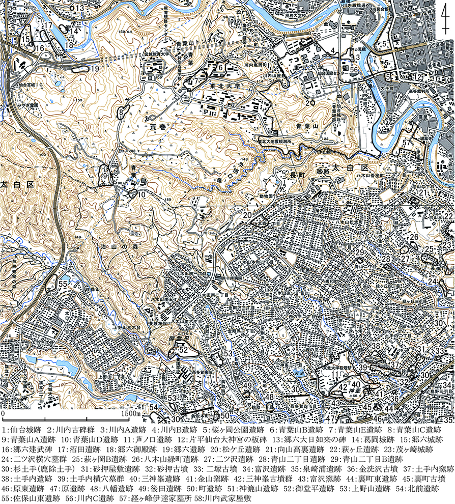
Archaeological Sites around Tohoku University
| 団地名 | 所在地住所 | 遺跡名 | 県遺跡番号 | 時代 | 備考 |
| 川内1 | 仙台市青葉区川内27-1・41他 | 仙台城跡 | 01033 | 近世 | 二の丸地区・二の丸北方武家屋敷地区・御裏林地区 |
| 仙台市青葉区川内12-2 | 川内古碑群 | 01386 | 鎌倉 | 弘安10年(1287)・正安4年(1302)他 | |
| 仙台市青葉区川内41 | 川内B遺跡 | 01565 | 縄文・近世 | ||
| 青葉山2 | 仙台市青葉区荒巻字青葉6-3 | 青葉山B遺跡 | 01373 | 縄文・弥生 古代 | |
| 仙台市青葉区荒巻字青葉6-3 | 青葉山E遺跡 | 01143 | 縄文・弥生 古代 | ||
| 青葉山3 | 仙台市青葉区荒巻字青葉468-1 | 青葉山C遺跡 | 01442 | 旧石器 | |
| 富沢 | 仙台市太白区三神峯一丁目101 | 芦ノ口遺跡 | 01315 | 縄文・弥生 古墳・古代 | |
| 川渡 | 大崎市鳴子温泉大口字蓬田 | 上川原遺跡 | 36006 | 縄文 | |
| 大崎市鳴子温泉大口字町 | 丸森遺跡 | 36038 | 縄文 | ||
| 大崎市鳴子温泉大口字町 | 東北大農場2・3号畑遺跡 | 36098 | 縄文 | ||
| 大崎市鳴子温泉大口字町西 | 町西遺跡 | 36106 | 弥生 | ||
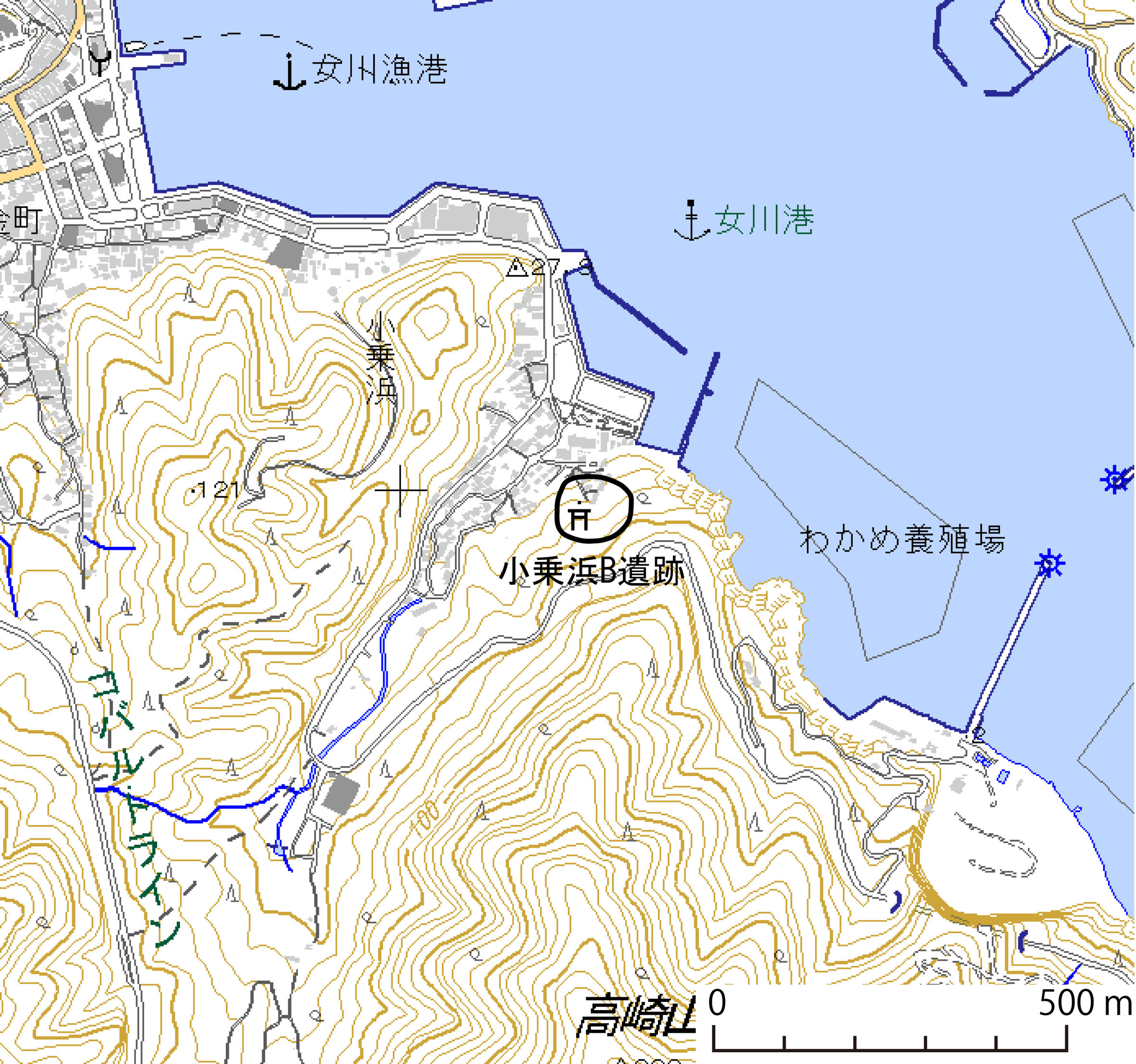
| 小乗浜 | 牡鹿郡女川町小乗浜 | 小乗浜B遺跡 | 73021 | 縄文 | 宿舎裏の山林部分 |
本表の「県遺跡番号」は、県の登録番号に拠る(「宮城の埋蔵文化財」参照)。
All excavations within the registered archaeological site boundaries require consultation with the Facilities Department and the Archaeological Research Office. Procedures will proceed in accordance with legal requirements. (Procedure leading to the investigation)
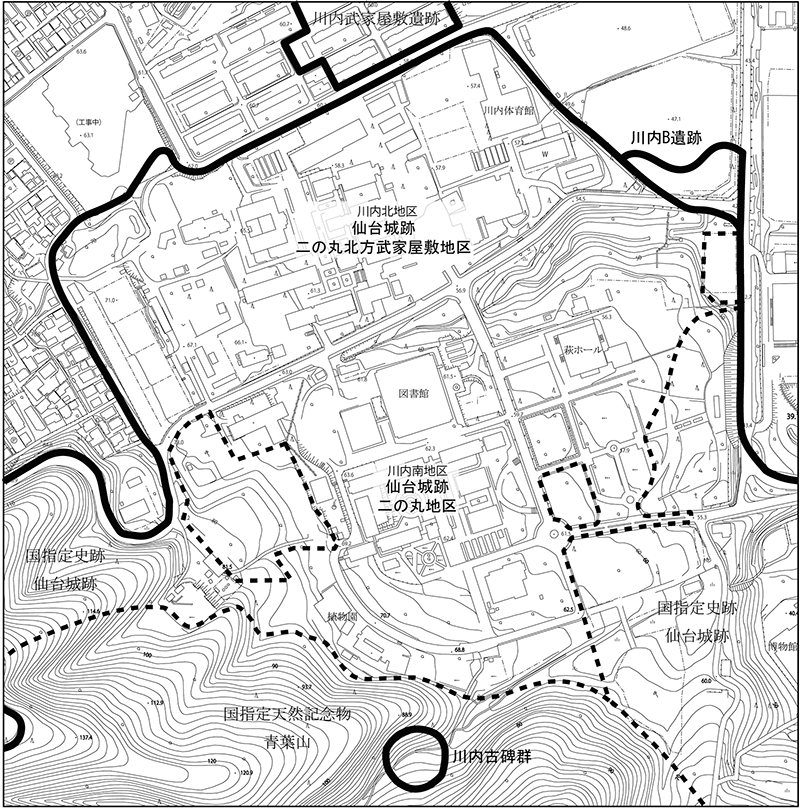
(1)The Ruins of Second Bailey in Kawauchi Area
この背景地図には、「仙台市都市計画図1/25000」を利用した。
Sendai Castle construction began in 1600 (Keicho 5) by Date Masamune, the first lord of the Sendai clan, starting with the current Honmaru (main bailey) area. It is said that Masamune's fourth son, Muneyasu, had his residence in what is now the Ni-no-maru area. In 1620 (Genna 6), the Nishi-yashiki (western residences) for Masamune's eldest daughter, Irohahime, was constructed. In 1638 (Kan'ei 15), the construction of the Ni-no-maru began under the second lord, Tadamune. Instead of Honmaru, various ceremonies of the Sendai Domain were held in the Ni-no-maru. Later, during the Genroku era (1688-1703) under the fourth lord, Tsunamura, large-scale renovations were carried out. Initially, the Ni-no-maru grounds were located more to the south, but they eventually expanded to encompass all of the western residence from Masamune's time and extended northwards.
After the Boshin War, the Sendai Domain's territory was significantly reduced, and the lord became the governor of the domain. Consequently, the Ni-no-maru housed the administrative offices of the domain. Following the abolition of the domains and the establishment of prefectures in 1871 Meiji 4), the area came under the jurisdiction of the Meiji government and was used as the headquarters of the Tohoku Chindai/army unit (Sendai Chindai). However, in 1882 (Meiji 15), a fire destroyed nearly 90% of the buildings. Subsequently, the site became the headquarters of the Second Division. After World War II, it was occupied by the U.S. military. In 1957 (Showa 32), the land was returned by the U.S. military and came under the management of Tohoku University, where it was used for the Department of Education and the Botanical Garden of the Faculty of Science. Since 1972 (Showa 47), the Faculty of Arts and Letters, Faculty of Education, Faculty of Law, Faculty of Economics, and the library have been located here.
In addition to the Sendai Castle Ni-no-maru and the Northern Samurai Residences areas, there are other archaeological sites such as the Kawauchi B Site and the Kawauchi Stone Stupa. The Kawauchi B Site was excavated by the Sendai City in conjunction with the construction of the Sendai City Rapid Transit East-West Line (Report on Cultural Properties of Sendai City No. 385, 2011). This excavation revealed ruins of wells and pillars from the 17th to 19th centuries, along with a large number of artifacts including ceramics. The Kawauchi Stone Stupa includes two steles with inscriptions dating back to the Kamakura period: 1287 (Koan 10) and 1302( Shōan 4). The former was erected to to pray for the repose of the soul of the lord of Mutsu Province. Detailed information, including the transcriptions and measured drawings, can be found in the "Sendai City History Special Edition 5: Itabi" (1993).
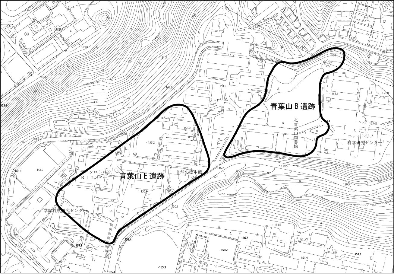
(2)Aobayama Area
この背景地図には、「仙台市都市計画図1/25000」を利用した。
The archaeological fieldwork (the Aobayama A, B, C and D sites) by the Tohoku University Archaeology Laboratory that began around Showa 46 (1971) and the research by the Tohoku University Archaeological Research Office (the Aobayama E site) have revealed that the Aobayama site group is mainly from the Paleolithic and Jomon periods. However, due to the discovery of the Paleolithic tool fabrication case, the Aobayama B site (Yearly Report 2) and the Aobayama E site's 5th survey (Annual Report 14) were found not to be appropriate as academic material (Annual Report 14, report by the Miyagi Prefectural Board of Education) with regard to the Paleolithic tools from the Aobayama E site (Annual Report 14). However, upper Paleolithic tools were excavated at Site C in Aobayama, which was surveyed in 2006 (Annual Report 24), and it is certain that Paleolithic sites exist.
For an overview of the surveys in the Aobayama area and published reports, see here (Past Research・Publication Information).
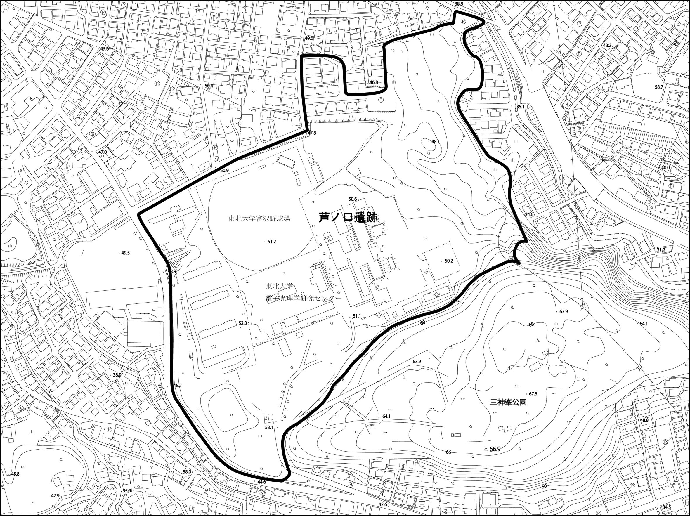
(3)Tomizawa Area
この背景地図には、「仙台市都市計画図1/25000」を利用した。
For an overview of the surveys in the Tomizawa area and published reports, see here (Past Research・Publication Information).
(4)Kawatabi Area

この背景地図等データは、国土地理院の電子国土Webシステムから配信されたものである。
(5)Onagawa Area
この背景地図等データは、国土地理院の電子国土Webシステムから配信されたものである。